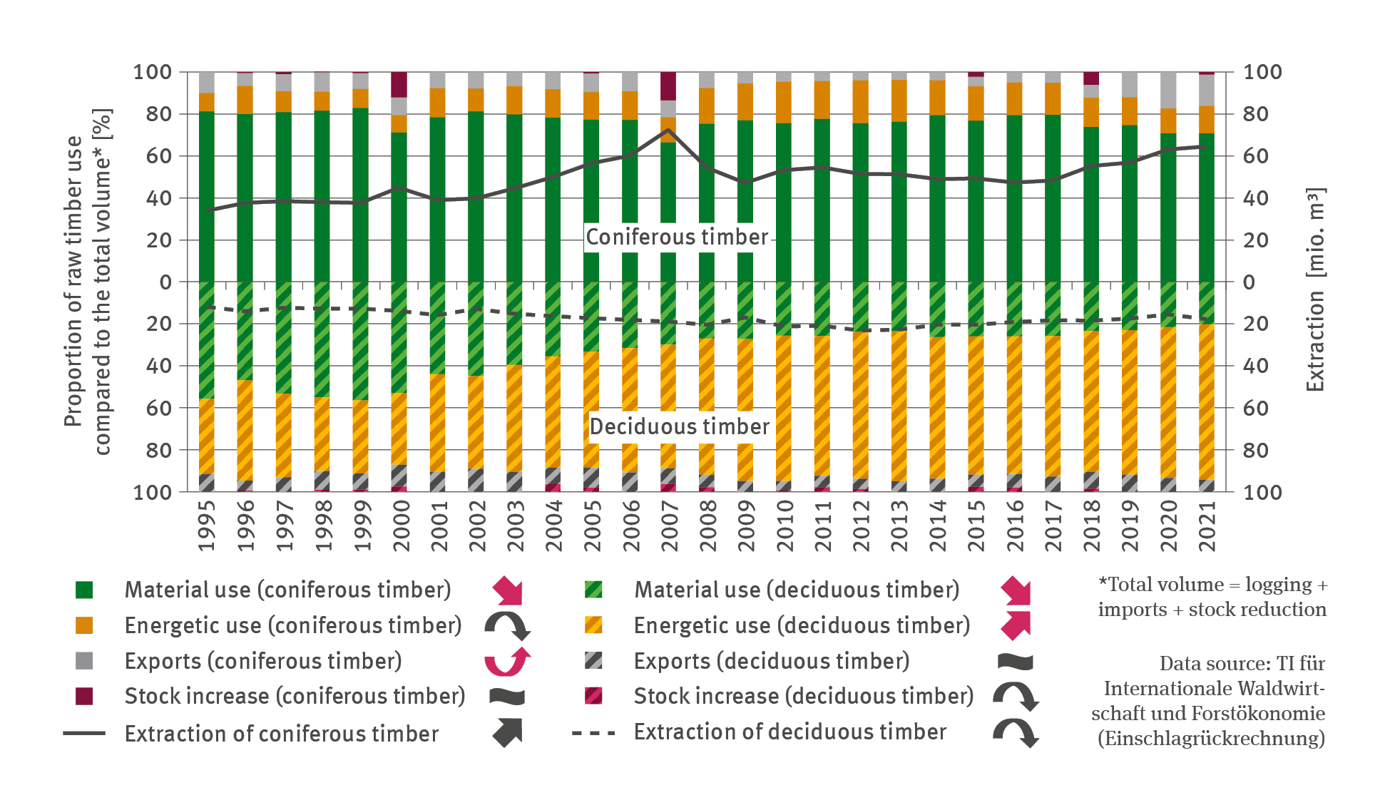
Skip to main content Skip to main menu Skip to footer

Data Search

Data Search

Here you will find diagrams, infographics, maps and tables for direct download.

Data Search

The illustration FW-R-3 ’Humus reserves in forest soils’ indicates – for the period of 1992 to 2021 – in the shape of a line chart, the annual reserves of organic carbon in forest soils in tonnes per hectare. During the observation period, carbon reserves increased continuously and significantly from roughly 75 tonnes per hectare to 85 tonnes per hectare.

FW-R-3: Humus reserves in forest soils

  • Klima
  • Land- und Forstwirtschaft
  • Diagramme
Export data
PNG
The line chart contains a biaxial chart indicating the total domestic sale of herbicides, fungicides, insecticides (without inert gases) for the period of 1991 to 2021 in volumes of active ingredients in units of a thousand tonnes.

LW-R-5: Sales and application of pesticides

  • Klima
  • Land- und Forstwirtschaft
  • Diagramme
Export data
PNG
The bar chart FW-R-2 ‘Conservation of forest-genetic resources’ indicates the terrain of stands dedicated to the purpose of genetic conservation on the natural site (in-situ) of the occurrence of species and of stands and seed plantations cultivated for the purpose of genetic conservation outside their natural occurrence (ex-situ) in the years of 2004, 2010, 2012, 2017 and 2022 respectively. In the period of 2004 to 2010, the total terrain of in-situ stands increased to roughly 32,000 hectares.

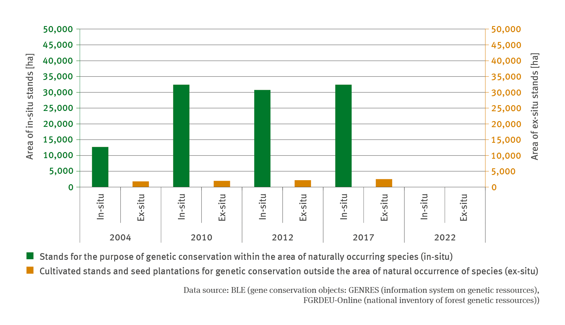
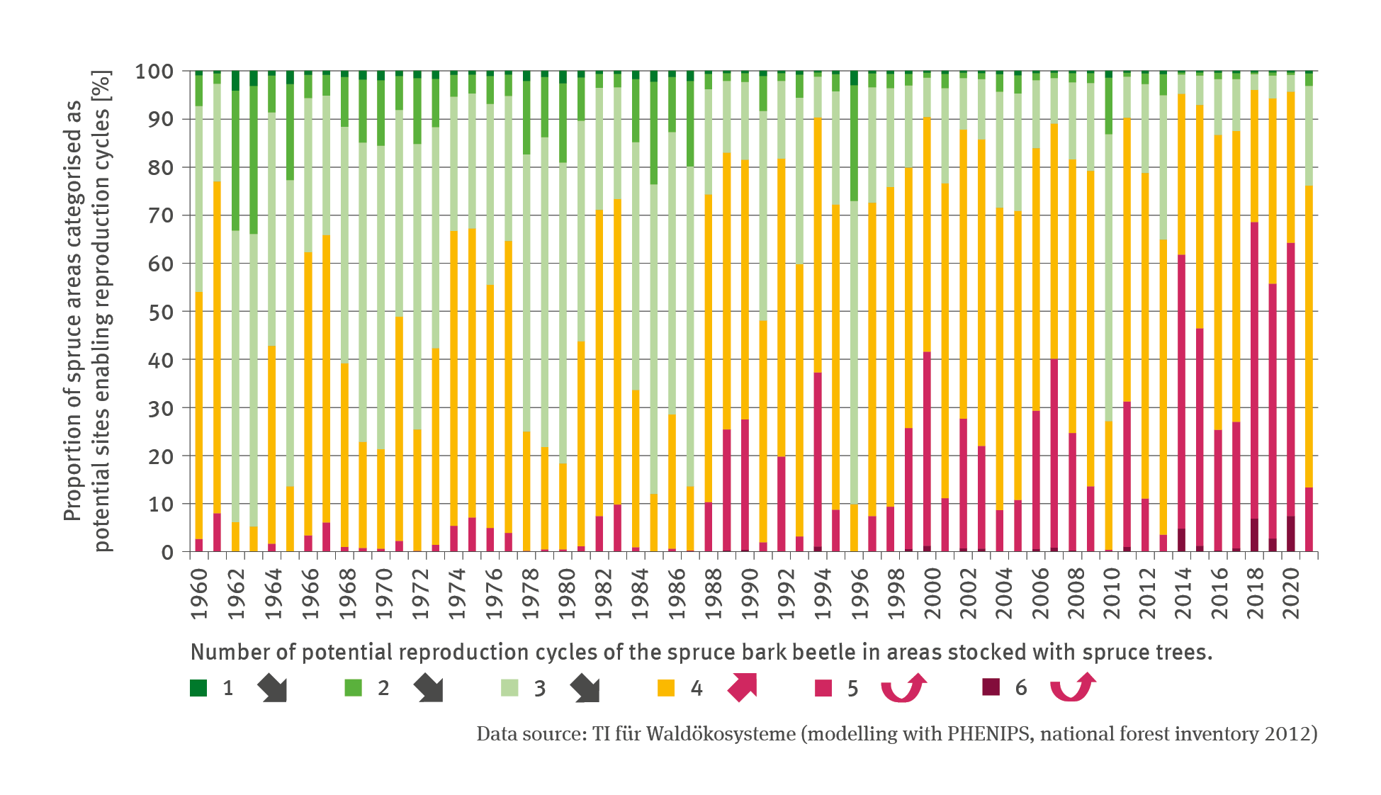
FW-R-2: Conservation of forest-genetic resources

  • Klima
  • Land- und Forstwirtschaft
  • Diagramme
Export data
PNG
The line chart indicates – for the period of 1991 to 2021 – the proportion of the varieties durum, grain maize, grain maize combined with CCM as well as soybeans in terms of the size of the cultivation terrain in per cent. In this context the term ’cultivation terrain’ denotes the total cultivation area or terrain used for the production of grain cereals, plants harvested green, root vegetables, pulses and industrial crops.

LW-R-4: Cultivation of thermophilic crops

  • Klima
  • Land- und Forstwirtschaft
  • Diagramme
Export data
PNG
The illustration FW-R-1 ’Financial support for forest transformation’ contains a biaxial diagram. The stacked column chart illustrates the annual investments in forest transformation in million Euros from 2000 until 2021.

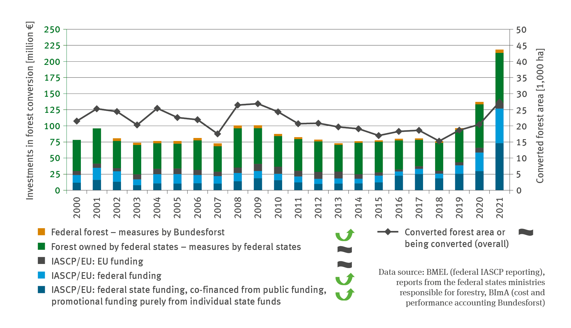
FW-R-1: Financial support for forest transformation

  • Klima
  • Land- und Forstwirtschaft
  • Diagramme
Export data
PNG
The illustration contains a biaxial chart. The chart illustrates, by means of lines for 1991 to 2021, the number of the varieties – of summer durum wheat, winter durum, soybeans and sorghum – certified. In recent years, the number of certified varieties in respect of all crops has risen – significantly so – in respect of soybeans and summer durum.

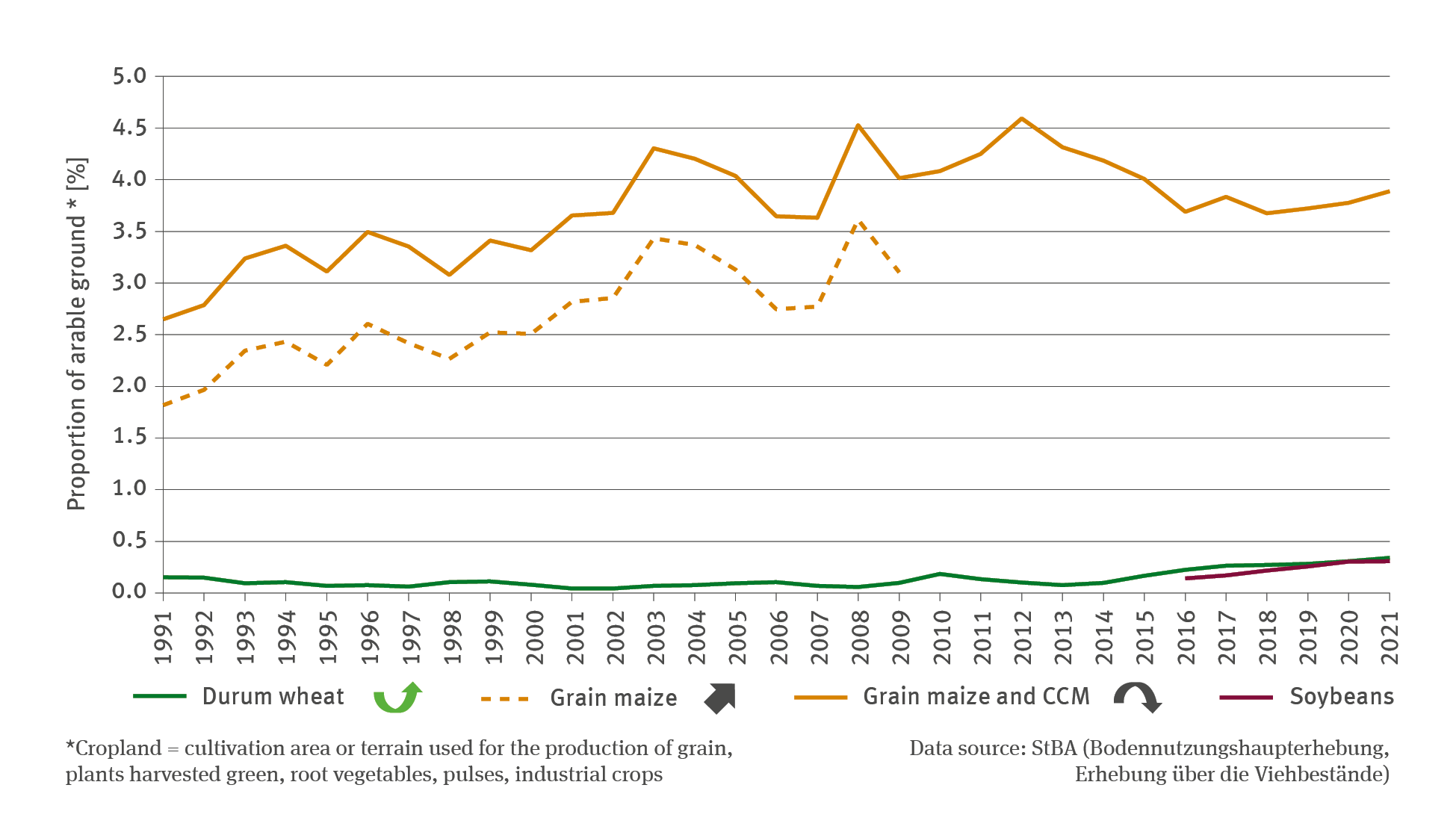
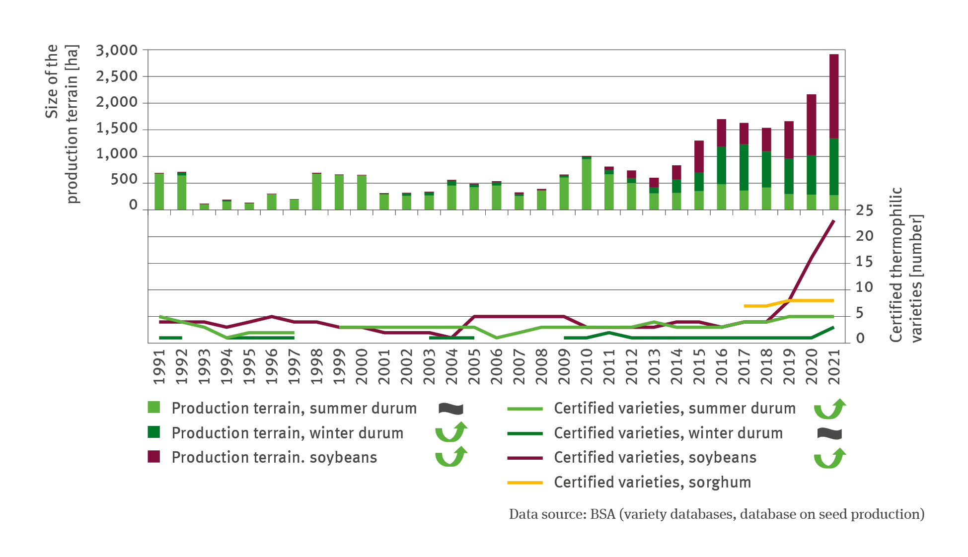
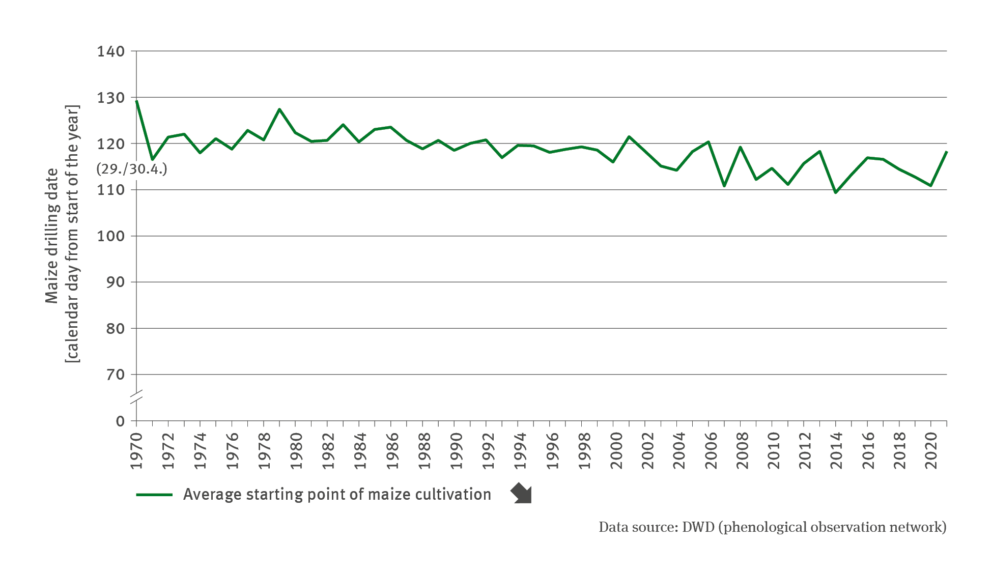
LW-R-2: Cultivation and propagation of thermophilic arable crops

  • Klima
  • Land- und Forstwirtschaft
  • Diagramme
Export data
PNG
The line chart indicates – for the period of 1970 to 2021 – the mean point in time when maize cultivation begins, in terms of a calendar date from the start of the year. Although the time series proceeds with some fluctuation, it shows a significantly falling trend: To date, the latest onset of drilling occurred in 1970 on day 130 of the year – early May. In 2021 drilling began as early as day 119 of the year – end of April.

LW-R-1: Adaptation of management rhythms

  • Klima
  • Land- und Forstwirtschaft
  • Diagramme
Export data
PNG
The stacked columns chart FW-I-6 ’Endangered spruce stands’ shows – for the period of 1960 to 2021 – the proportion in per cent of areas in Germany planted with spruce trees, in which the spruce bark beetle would be able to achieve a specific number of potential reproduction cycles. In this process, a differentiation was made between the number of potential reproduction cycles between 1 and 6.

FW-I-6: Endangered spruce stands

  • Klima
  • Land- und Forstwirtschaft
  • Diagramme
Export data
PNG
The illustration LW-I-4 ’Infestation with pest organisms – case study’ contains a biaxial chart. The lines in the chart indicate the infestation of winter wheat with brown rust and powdery mildew by stating the percentage of infested plants. In respect of winter rapeseed, the chart indicates the maximum infestation with rape beetle by stating the number of beetles per plant. There are data available from Saxony-Anhalt – with very few data gaps – for winter wheat from 1976 to 2021.

LW-I-4: Infestation with pest organism – case study

  • Klima
  • Land- und Forstwirtschaft
  • Diagramme
Export data
PNG
The illustration FW-I-5 ’Damaged timber – extent of random use’ contains a biaxial chart. The chart shows the proportion of random use compared to the logging total in per cent as a line, and the proportion of damage causes compared to the total of random use in per cent in terms of stacked columns. A differentiation is made between causes such as wind/storm, insects and other causes. The proportion of random use decreased steadily until the turn of the century, amounting to roughly 10 per cent in 1999.

FW-I-5: Damaged timber – extent of random use

  • Klima
  • Land- und Forstwirtschaft
  • Diagramme
Export data
PNG

You can also search in other data portals of the German Environment Agency

Short link: www.umweltbundesamt.de/n300701en