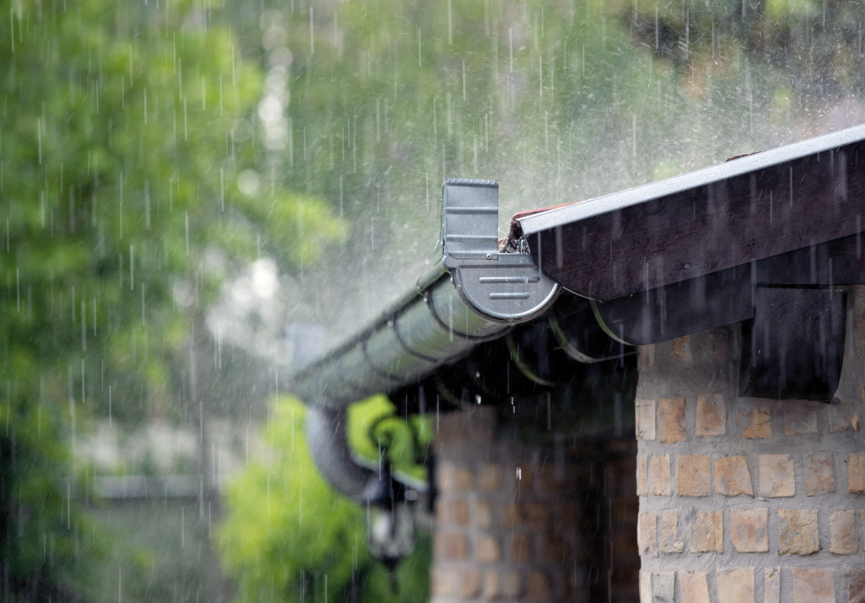
Heavy rain is a weather event in which massive amounts of rain fall within a very brief period of time. The DWD issues torrential rain warnings when it is expected that within one hour more than 25 litres per square metre (l/m²) or in six hours more than 35 l/m² rain is expected to fall. Amounts of rain amounting to more than 40 l/m² in one hour or 60 l/m² in three hours falling in these time periods are classed as extremely severe weather. Frequently these cloud bursts occur when massive clouds – formed as a result of convection – open their floodgates causing torrential rain to fall on mostly small areas.
Typical examples showing the impacts of short-term heavy rainfall are depicted in images existing for Braunsbach in Baden-Württemberg (May 2016) or from Berlin (June 2017): It can be a matter of just a few minutes for torrential rain to make sewers overflow and flooding entire street networks. Torrential rain can cause flash floods engulfing cars and devastating streets and buildings. In extreme cases, such events can endanger life and limb of the local population and cause significant material damage. In 2021 for example, the insured damage to residential properties, household effects and business premises from flooding and heavy rain totalled approximately 9.2 billion Euros.
During or after heavy rainfall, damage is caused primarily by so-called flash floods. These are extreme floodwater events as a result of heavy rainfall. They occur in lowland areas when rainwater cannot drain or seep into the ground fast enough. In those cases water accumulates on the surface or it dams up owing to overburdened sewage and drainage systems as their ultimate design loads are exceeded. Water levels can rise very rapidly then, especially in hollows and underpasses. On sloping terrain this can cause so-called ‘mountain flash floods’. The quick-draining water will accumulate in gutters or stream beds and can swell extremely rapidly forming surge-like floodwater waves. These waves are able to reach areas where no rain had fallen previously.137 When such mountain flash floods sweep away material such as trees or rocks, they can cause massive damage to houses or culminate in the complete loss of buildings.
Heavy rain and flash floods can, however, damage buildings in other ways too. For example, standing water can reach levels which exceed the design threshold thus enabling water to enter the building, for instance through entrance doors at ground level, cellar windows or owing to tailbacks in the sewage system. The ingress of water then leads to the distribution of mud and detritus which may be polluted additionally by a mixture of mineral oil, chemicals and faeces. Above and below the earth’s surface, standing water or high soil humidity can cause typical floodwater damage to the fabric of buildings, such as moisture penetration and linear water level marks, efflorescences on surfaces, detached coatings or fungus. In order to prevent damage, house proprietors can take a number of measures, possibly by placing building apertures at a sufficient height above ground level, the use of waterproof building materials and appropriate drainage systems with backflow preventers.138 (PDF, 9.0 MB, accessible)
According to current scientific knowledge, collated by the IPCC as published in February 2022 in the second part of the 6th Assessment Report139, it is possible to discern an increase in the frequency and intensity of extreme weather events as a result of climate change. As climate warming keeps progressing, climate risks will increase worldwide and that includes Germany. Experts in the fields of meteorology and climate research expect more frequent and more extreme heavy precipitation events to occur in Germany in the future. One reason for this is that at higher temperatures the air can absorb more water – approximately seven per cent more water with each temperature increase per Kelvin. Furthermore, it is to be expected that owing to changed meteorological circumstances during the formation of showers and thunderstorms, the formation of clouds and precipitation will intensify. During the second half of the 21st century, Germany – albeit with major regional and seasonal differences – will experience a distinct increase in the incidence of daily precipitation amounts compared to the relatively infrequent occurrence experienced at present.140 (PDF, 5.4 MB) 140 (PDF, 0.7 MB, non-accessible) 140 (PDF, 0.5 MB, accessible) 140
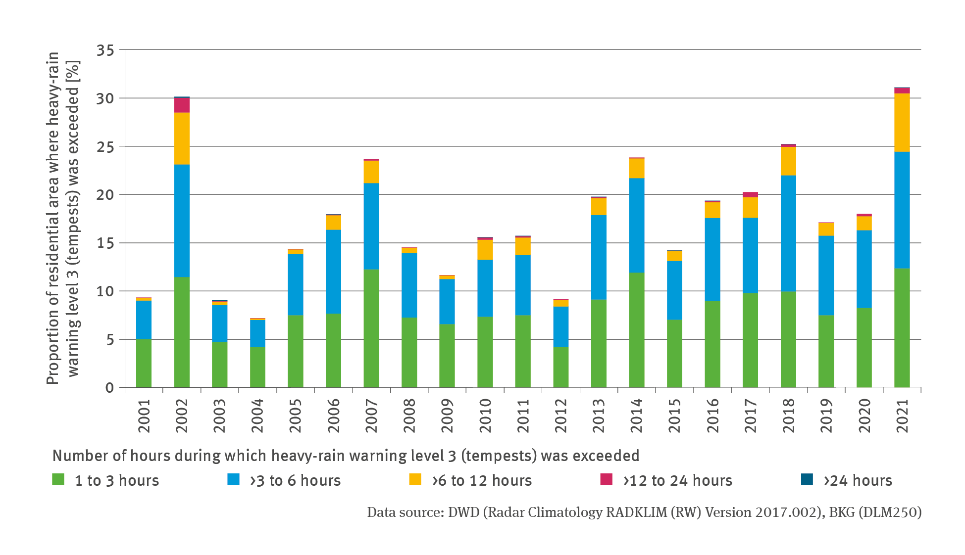
It is difficult to assess the frequency and intensity of heavy rainfalls and whether climate warming already has an impact on these events. Heavy rain events often just occur in spatially limited localities and therefore are not all recorded by the meteorological station network. This is one of the reasons why the DWD has developed a method of radar-based precipitation recording which since 2001 has enabled the acquisition of almost comprehensive precipitation data.141 This dataset contains nearly all heavy rain events that occurred in Germany since 2001. The prolongation of this system of data acquisition will in future also facilitate trend analyses of the frequency of cases when the warning thresholds applied by the DWD are exceeded.
In the illustration for the indicator concerned, the annual data from the radar-based precipitation measurements were superimposed on the data for Germany’s residential terrain. The years of 2002 and 2021 stand out from the overall picture with a particularly high number of built-up areas being affected by many hours of heavy rainfall. This is linked to extensive areas with persistent rainfall (in terms of the warning criteria applied by the DWD for rainfall during a period of 12 to 72 hours), in which the threshold values for heavy rain warnings were also exceeded temporarily. In 2002 numerous events of heavy rainfall during an extended period in Saxony and South Bavaria caused floodwater disasters involving the rivers Elbe and Danube. In July 2021 massive rainfalls triggered flooding in the Ahr and Erft valleys which had disastrous consequences. During a period of stable low-pressure weather conditions almost 95 litres of rain per square metre fell in the Ahr’s entire catchment area within just 24 hours. Some meteorological stations in other parts of the Rhineland-Palatinate and North Rhine-Westphalia measured values in excess of 150 litres of rain per square metre falling within 24 hours. Owing to humid weather conditions having prevailed in the preceding weeks, soils were unable to absorb much rain; moreover the existing geological circumstances generally impede seepage. On the steep slopes of the upland region, the rainwater quickly ran off the surface, accumulating in narrow – in some cases heavily built up – river valleys where it left a trail of destruction (cf. Indicator BAU-I-5).
137 - BBK – Bundesamt für Bevölkerungsschutz und Katastrophenhilfe (Hg.) 2015: Die unterschätzten Risiken „Starkregen“ und „Sturzfluten“ – Ein Handbuch für Bürger und Kommunen. Bürgerinformation, Ausgabe 1, Bonn: 27. https://www.bbk.bund.de/SharedDocs/ExterneLinks/DE/Download/starkregen-publikation-kurzlink.html
138 - Bundesministerium für Wohnen, Stadtentwicklung und Bauwesen (Hg.) 2022: Hochwasserschutzfibel. Objektschutz und bauliche Vorsorge. Berlin, 81 pp. https://www.fib-bund.de/Inhalt/Themen/Hochwasser/
BBSR – Bundesinstitut für Bau-, Stadt- und Raumforschung im Bundesamt für Bauwesen und Raumordnung (Hg.) 2018: Starkregeneinflüsse auf die bauliche Infrastruktur. Bonn: 19ff. https://www.bbsr.bund.de/BBSR/DE/veroeffentlichungen/sonderveroeffentlichungen/2018/starkregeneinfluesse.html
BBK (Hg.) 2015b: Empfehlungen bei Unwetter – Baulicher Bevölkerungsschutz. Bürgerinformation, Ausgabe 1. Bonn: 27ff.
139 - IPCC – Intergovernmental Panel on Climate Change 2022: Zusammenfassung für die politische Entscheidungsfindung [H.-O. Pörtner, D.C. Roberts, E.S. Poloczanska, K. Mintenbeck, M. Tignor, A. Alegría, M. Craig, S. Langsdorf, S. Löschke, V. Möller, A. Okem (Hrsg.)]. In: Klimawandel 2022: Folgen, Anpassung und Verwundbarkeit. Beitrag der Arbeitsgruppe II zum Sechsten Sachstandsbericht des Zwischenstaatlichen Ausschusses für Klimaänderungen [H.-O. Pörtner, D.C. Roberts, M. Tignor, E.S. Poloczanska, K. Mintenbeck, A. Alegría, M. Craig, S. Langsdorf, S. Löschke, V. Möller, A. Okem, B. Rama (Hrsg.)]. Deutsche Übersetzung (korrigierte Version) auf Basis der Version vom Juli 2022. Deutsche IPCC-Koordinierungsstelle, Bonn; Die Luxemburger Regierung, Luxemburg; Bundesministerium für Klimaschutz, Umwelt, Energie, Mobilität, Innovation und Technologie, Wien; Akademie der Naturwissenschaften Schweiz SCNAT, ProClim, Bern; Mai 2023. doi: 10.48585/rz5m-2q42
140 - Kahlenborn W., Porst L., Voß M., Fritsch U., Renner K., Zebisch M., Wolf M., Schönthaler K., Schauser I. 2021: Klimawirkungs- und Risikoanalyse 2021 für Deutschland – Kurzfassung. Umweltbundesamt (Hg.). Climate Change 26/2021‚ Dessau-Roßlau, 121 pp. https://www.umweltbundesamt.de/publikationen/KWRA-Zusammenfassung
DWD – Deutscher Wetterdienst (Hg.) 2016: Starkniederschläge in Deutschland. Offenbach am Main: 1. https://www.dwd.de/DE/leistungen/klimareports/download_einleger_report_2016.pdf
Becker P., Becker A., Dalelane C., Deutschländer T., Junghänel T., Walter A. 2016: Die Entwicklung von Starkniederschlägen in Deutschland – Plädoyer für eine differenzierte Betrachtung: 1. https://www.dwd.de/DE/fachnutzer/wasserwirtschaft/entwicklung_starkniederschlag_deutschland_pdf
LAWA – Bund/Länder-Arbeitsgemeinschaft Wasser (Hg.) 2018: LAWA-Strategie für ein effektives Starkregenrisikomanagement. Erarbeitet von der Kleingruppe „Starkregen“ des Ständigen Ausschusses „Hochwasserschutz und Hydrologie“ (LAWA-AH) der LAWA. Ministerium für Landwirtschaft, Umwelt und Klimaschutz des Landes Brandenburg, Potsdam: 2024. https://www.lawa.de/documents/lawa-strategie-srrm-final-barrfrei_1726058183.pdf
141 - Winterrath T., Brendel C., Hafer M., Junghänel T., Klameth A., Lengfeld K., Walawender E., Weigl E., Becker A. 2018: RADKLIM Version 2017.002: Reprozessierte, mit Stationsdaten angeeichte Radarmessungen (RADOLAN), Niederschlagsstundensummen (RW). doi: 10.5676/DWD/RADKLIM_RW_V2017.002