Ecological processes in a lake are influenced substantially by water temperature. An examination of the onset of spring algal bloom reveals relevant changes in water ecosystems, as the spring algal bloom is on one hand dependent on circulation conditions and stratification of water layers in a lake, while on the other, spring algae are very important building blocks in a food web.
There is a direct connection between climate change, ice cover in winter, the onset or end of thermal stratification and the water temperature of a lake, as well as the temporal onset of spring algal bloom. When winter ends with surface water warming thus ending the stagnation typical of winter, prompting the onset of spring circulation, nutrient-rich water is transported from the depth of a lake to its surface while water rich in oxygen is transported deep down. Provided this coincides with the presence of sufficient light, this scenario will trigger a growth phase in phytoplankton. This spring algal bloom will fade once the nutrients have been used up, the stability of stratification increases and foraging pressure is brought about by zooplankton thus creating a clear-water phase. Increased filtration rates thanks to the presence of mussels can also reduce the amount of phytoplankton.
Higher winter and spring temperatures can lead to an earlier onset of algal bloom, increase the algal growth rate and change the species composition. The earlier onset of algal bloom indicates that summer stagnation will begin earlier too. The stratification typical of the summer season, puts an end to the exchange of nutrients and oxygen among the layers. Consequently, this causes a depletion of oxygen in the deeper water layers – the
hypolimnion – especially, when the stable stratification lasts unusually long owing to warmer autumn temperatures. The potential dissolution of nutrients in the sediment caused by anaerobic conditions can lead to eutrophication.
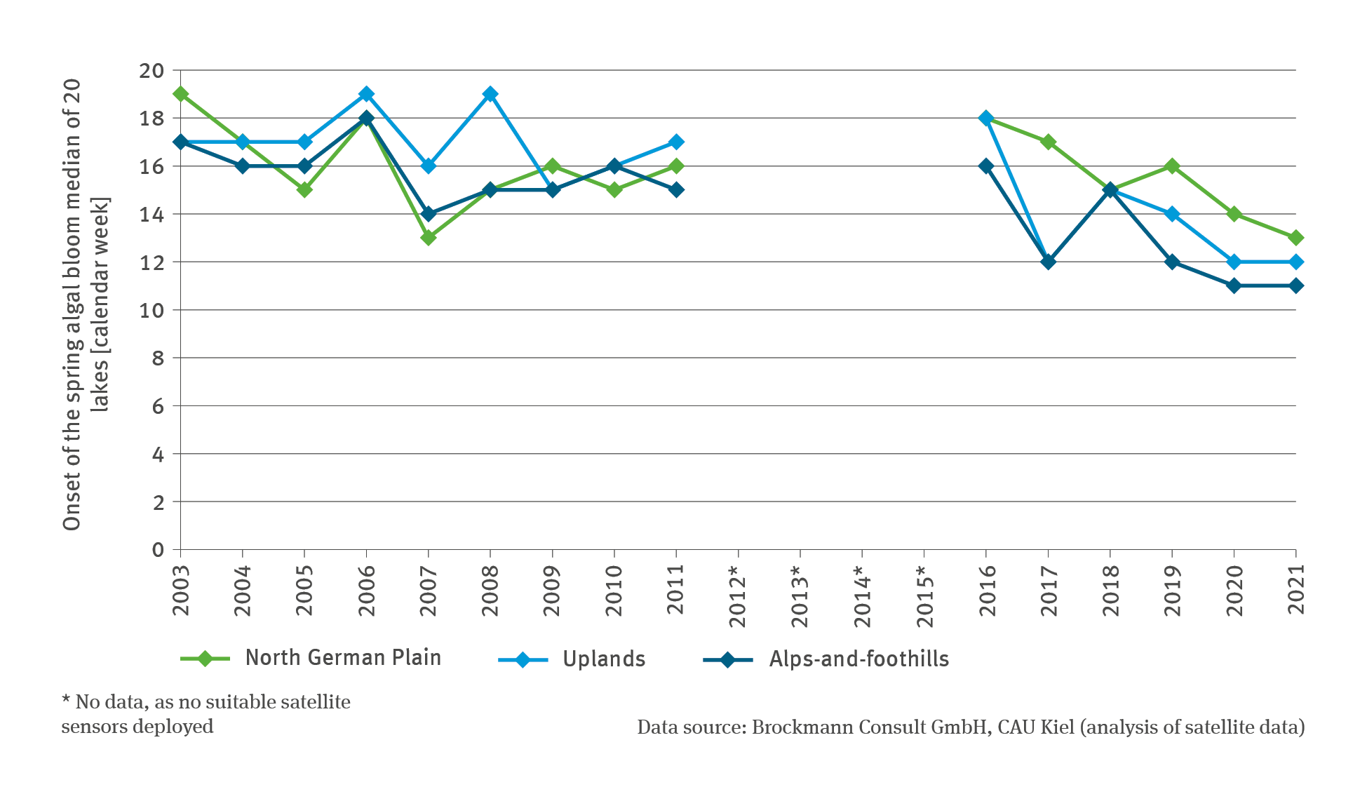
The indicator shows the temporal shift of the onset of spring algal bloom based on data for 20 lakes in Germany. Five lakes each are located in the Alps-and-foothills and the uplands region, while 10 of the lakes are located in the North German Plain. The differentiation by region is necessary, in order to take into account the different macro-climatic baseline conditions as well as the morphological differences between the lakes in these regions.
Given that there are few data available from on-site surveys regarding the point of onset, the indicator was developed on the basis of satellite data. These data made a distinctly broader spatial coverage of lakes possible. The reflexion of chlorophyll-a in the algae can be captured by means of satellites. The high temporal resolution provided by the data available is the crucial factor for a (timely) recognition of spring algal bloom: The interval between repeat flights is between one and two days. The determination of the (first) localised maximum is based on valid satellite photos and is limited by cloud cover, fog or ice cover. The exact temporal recognition of spring algal bloom on the basis of satellite data is therefore dependent on cloudless periods. This can mean that an event of spring algal bloom simply cannot be captured owing to weather-related influences. Given that the first maximum only lasts for a few days, the bloom might also occur just at a time between two observation flights. This shows that the capture of images by satellite has its own limitations. For all 20 lakes, the data series are available at a spatial resolution of 300 metres for the years 2002–2012 and 2016–2020 respectively. In the years between, there were no satellites active that were equipped with appropriate satellite sensors.
While the mean of the first four years of the time series shows that the spring algal bloom occurred – according to region – between the end of the 16th and the middle of the 17th calendar week, that is to say, between the middle and end of April, the first maximum bloom occurred – based on the mean of the last four years of the time series – already between the beginning of the 12th and the middle of the 14th week, in other words between end of March and the beginning of April. Given the disrupted time series, it made no sense to carry out a statistical trend analysis. However, the illustration of the time series demonstrates that a remarkable forward shift occurred in the space of a relatively short period of time in all regions leading to a much earlier onset of algal bloom. In addition, this diagnosis is reinforced by the earlier onset of the phenological spring phases (cf. Indicator BD-I-1).
The overall extraordinarily warm year of 2018 followed a mild winter although there was a very cold spell in February. All over Germany it was permanently frosty with two-digit degrees below zero occurring in most areas. There was another significant spell of cold air prevailing in March of that year. This is a major reason for the onset of spring algal bloom in 2018 occurring later compared to subsequent years. In early April the weather in the whole of Germany made a transition from winter to summer weather in a matter of just a few days. In the second week of April, the first maximum spring algal bloom occurred across three regions with major synchronicity.
The winter of 2018 / 2019 was very mild, with plenty of sunshine, subsequently followed by a mild March and a warm April. The scenario was very similar in 2020: After what had been the second-warmest winter since records began in 1881, Germany was under the influence of mostly warm air masses in spring, and it was unseasonally warm as a result. Consequently, spring algal bloom started early in those two years. However, the equally early bloom in 2021 is harder to put into context with the weather patterns prevailing at the time. Although the winter of 2020 / 2021 was unusually mild, it was followed by comparatively cool spring.