In the distinctly greater part of Germany, the natural discharge regime of watercourses is determined by rainfall. During the warm season, the degree of evaporation also plays a role. This leads to high mean values of discharge rates in winter and early spring, compared to low discharge values in late summer and autumn. Especially in the southern parts of Germany, winter snow cover as well as rain play a crucial part in the discharge regime. In alpine catchment areas with major rivers such as the Iller, Isar, Lech and Inn, winter precipitation often accumulates as snow; therefore discharge is lowest at that time of year. As a result of snow melt in spring and early summer, often accompanied by rainfall, maximum discharge occurs in the middle of the year. This is termed a nival discharge regime.
Apart from precipitation, the catchment area’s topography and the substrate play an important role; these factors are crucial for the speed at which precipitation actually affects the discharge regime.
Where climate change affects the precipitation and temperature conditions, it will also affect the discharge regime. Consequences may include impacts on the volume of the total discharge of water and on the seasonal distribution of discharge.
For an analysis of discharge regimes and their development, levels from a total of 76 gauging stations across Germany’s river catchment areas were selected. They represent mean catchment area sizes at a scale of 250 to 2.500 square kilometres. These are levels from gauging stations that are, as far as possible, unaffected by anthropogenic influences; in other words, this refers to runoff depths which were observed as not being strongly influenced by, for instance, water transfer systems or water retention systems.
The mean discharge of water (MQ) or the annual runoff depth (Ah), derived in relation to the size of the catchment area concerned, are indicative of the availability of water. This indicator shows the availability of water in principle, including water which is available for cultivation and for a variety of surface water uses such as cooling water or shipping. Changes in the mean discharge values can also entail changes in groundwater levels near banks (cf. Indicator WW-I-2) thus affecting supplies of drinking water and process water. Besides, the water level and associated flow rates are just as important for nearly all ecological functions of water bodies.
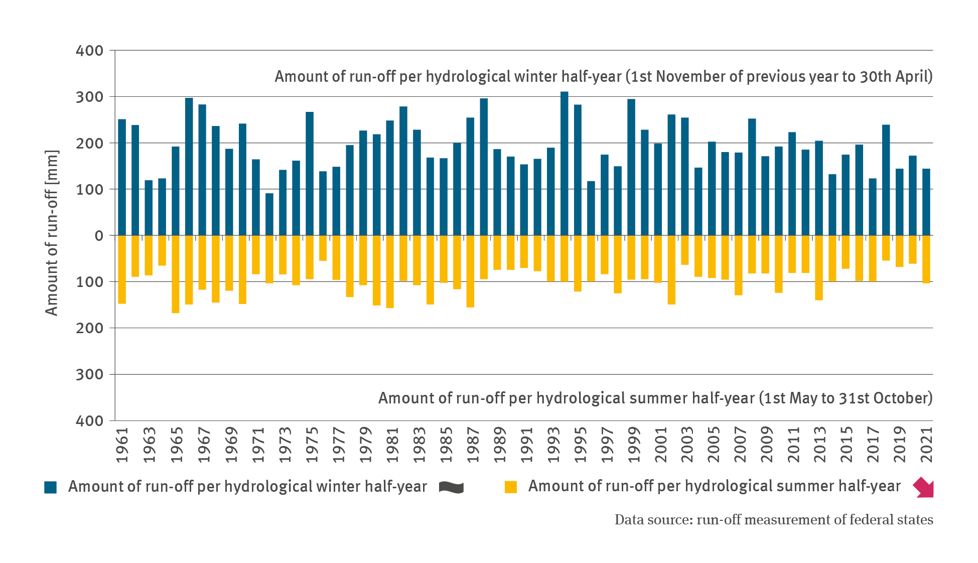
Although the time series from the 1960s onwards shows a slight decline in the mean discharge value for the hydrological half-year period from early November to end of April, this cannot be regarded as a statistically significant trend. However, during the hydrological summer half-year, in other words, from early May to end of October, a significant falling trend can be discerned. This is due to reduced precipitation in summer and temperature-related higher evaporation during those months. These developments suggest that changes in the fundamental availability of water in both half-years (winter and summer) are already beginning to take place.
The mean value calculated across Germany, is – owing to the effects of precipitation and evaporation on the winter discharge values – clearly higher in general than the discharge values for the summer half-year. The low-water year of 1972 is the only year in the time series considered when the summer discharge values were a little higher than the winter values. Since then there has not been a single year when this happened again. Nevertheless, the relationship between the mean discharge in the summer half-year and the winter half-year does not suggest any changes that can be described as statistically significant.
In the Danube river basin where the discharge regime is characterised by a predominantly nival discharge regime, there have been – from 1960 until the late 1980s – just as many years in which the values for summer discharge were higher, as there were years in which the winter discharge values were higher. Since 1990 the years in which winter discharge values exceeded summer discharge values have increased in frequency. This suggests that the influence of the snow cover on the discharge regime is diminishing.