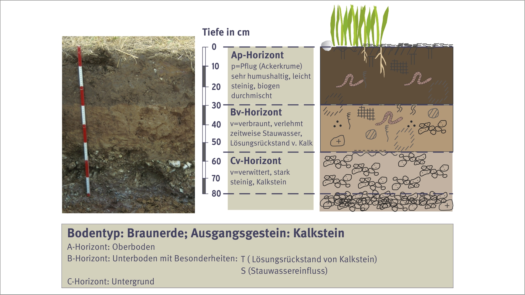
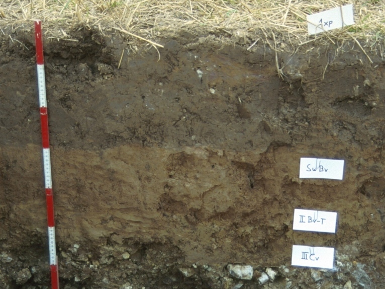
Click to enlargeBrown earth, one of the many types of strong soil. Source: S. Marahrens / Umweltbundesamt
Specific types of soil with their own inherent properties form over a lengthy period as the result of the interplay between a host of environmental factors. Germany has a closed soil covering that is strong in many locations and forms a patchwork of many different types of soil.
1469
Strong soils
Germany’s soils are systematically classified in a manner that takes account of their developmental timelines and varying properties, i.e. on the basis of differential criteria that can be allocated through careful study of excavated soil or drill cores. In this process, sub-types can be differentiated on the basis of anything from very broad to extremely finely granulated criteria, whereby the former are based on the fact that water has more impact on soil development than any other factor.
Virtually all soil investigations centre around terrestrial soils, whose development is primarily shaped by the rainwater that is transported into soil pores after seeping into the ground. Terrestrial soils are differentiated according to their respective determining soil formation processes. Typical soil types include black earth and brown earth, with subsequent differentiation levels comprising the soil types per se. Soil types are classified according to characteristic soil strata, which occur in a specific order depending on type. The more finely granulated subdivisions characterize subtypes, so as to allow for differentiation of the specific characteristics of the 56 types of soil.
The upper level of description comprises terrestrial and semi-terrestrial soils that are affected by groundwater that occurs for varying periods. One representative of this group is alluvial soil in the courses of streams and on riverbanks that are partly or periodically covered with water. Semi-subhydric and subhydric soils are temporarily or permanently flooded; a well known representative of this soil type is mudflat soil. The fourth group comprises fens and mires, whose salient characteristic is a permanent state of water surfeit that is attributable to the fact that little in the way of broken-down plant residues accumulate in the form of peat. The most familiar types are fens and mires.
Classifying soils enables scientists to characterize the ecological properties of a given site without engaging in lengthy investigations. For example, black earth always exhibits a very specific stratum structure, which along with its properties, make it Germany’s best farming soil.
Stratum structure
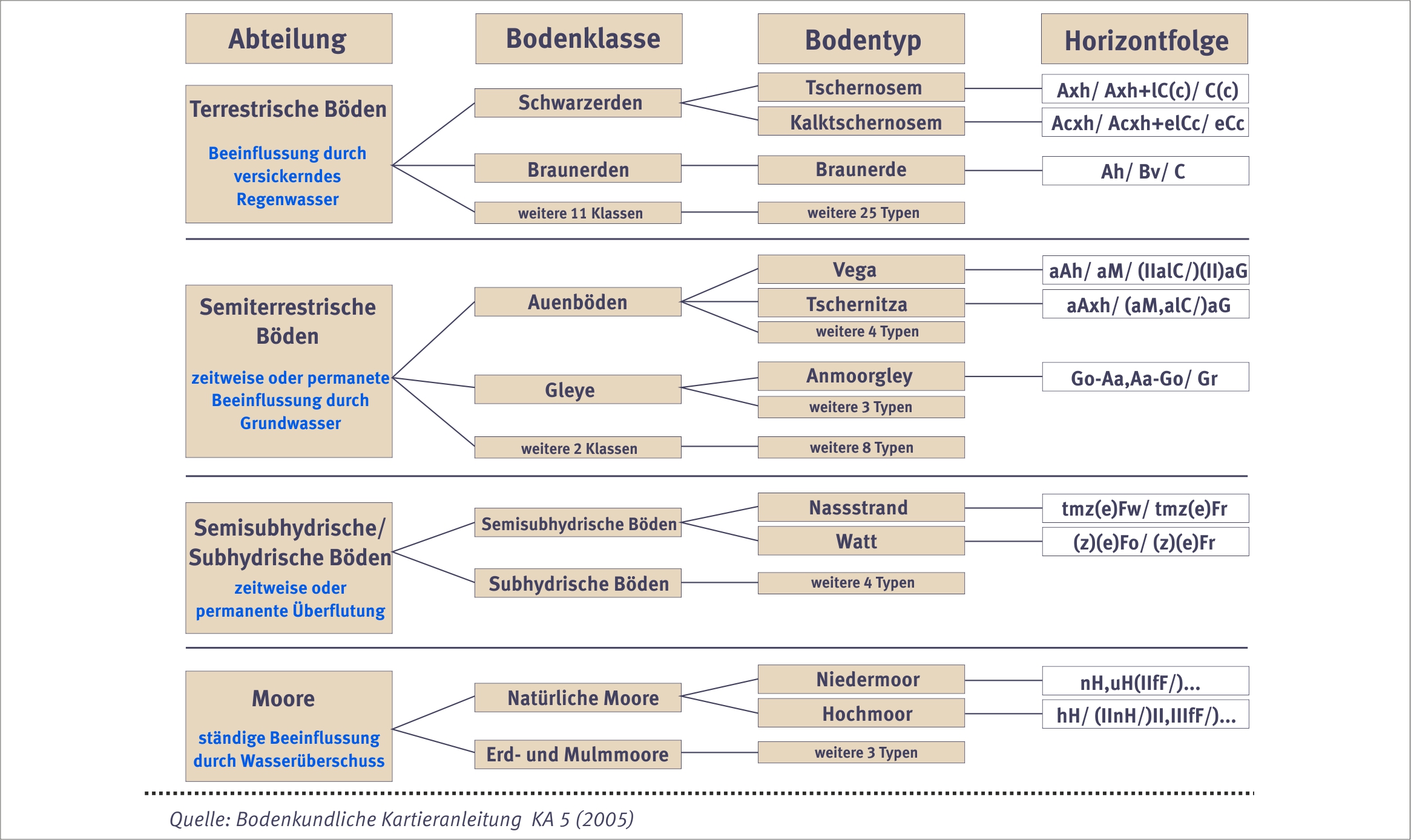
The verticality of strata allows for the differentiation of various types of soil and soil structures. The various soil strata, which are formed by various soil development processes, represent the current development status of a given soil. The numerous main symbols that are used for strata labeling purposes are assigned to the three main stratum categories, namely semi-subhydric/subhydric strata, organic strata and mineral strata. The latter account for the lion’s share of soil strata. The vertical arrangements correspond sequentially to the A, B and C strata, whereby these letters respectively stand for the upper strata, the lower strata and the still lower hybrid zone between the soil and rock substrate.
The main symbols are represented by lower case letters that describe the geological or anthropogenic particularities of a given stratum. The letter “a” stands for “alluvial dynamics,” which indicates that the stratum is subject to flooding. The letter “r” stands for relict, which documents that original conditions and influences are no longer dominant.
The lower case letters after the main symbols provide information concerning the determining soil properties and the dominant soil formation processes. For example “h” stands for “humus,” the dark colored topsoil, while “p” stands for a field’s plowed humus topsoil, which is clearly differentiated from the stratum just below it. The various symbols are assigned on the basis of specific criteria and possible combinations which, in conjunction with the description of the soil type in question, to some extent allow for comparisons between the various types of soil.
Extract of soil systematics in Germany Source: S. Marahrens / Umweltbundesamt
Schematic representation of a soil profile based on brown earth. Source: S. Marahrens / Umweltbundesamt
The diversity of soils in Germany also reflects the country's different landscapes and the varying rock conditions underground. A soil map is by nature always a simplified image due to the small-scale changes in soil types and soil properties. It is therefore not possible to describe soil at every single location. There are also limitations to imaging on maps themselves. There are soil maps in Germany on all scale levels which vary somewhat from one federal state (Land) to the next. The map at national scale level requires a great simplification of the information in order to portray the basic distribution of soils. Soil maps for the whole of Germany are drawn by the Federal Institute for Geosciences and Natural Resources (BGR) in Hanover. For historical reasons, pedological mapping and the description of soils are often the responsibility of other institutions since statutory soil protection is a young discipline. The soil map of Germany at scale 1:1,000,000 (BÜK 1000) and the even more simplified soil map at scale 1:5,000,000 (BÜK 5000) of the BGR are well-suited for depicting the different soils in Germany.
It is immediately apparent when looking at the map that soil differs in accordance with the geography of the uplands, the river valleys, and the landscapes formed during the Ice Age in northern Germany. These differences are reflected very well in the rock formations in Germany, as shown in the map of parent rock material (BAG 5000). The characteristics of the bedrock are closely linked to the development of soil. The federal states have more detailed soil maps up to scale 1:5,000 or have access to soil surveys and maps in many locations in the respective federal state. Knowledge about the distribution of soils and the collection and archiving of information about soil properties are an important part of the work done by the public authorities responsible for soil protection. This information provides the basis for evaluation and for the recommendation of measures to handle the soil impairments which affect soils today.
The UBA’s motto, For our environment (“Für Mensch und Umwelt”), sums up our mission pretty well, we feel. In this video we give an insight into our work.
The UBA
Contact
Wörlitzer Platz 1 06844 Dessau-Roßlau GermanyPlease send us your enquiries exclusively via the contact form.
Due to the large number of enquiries, there may be delays in responding. We ask for your understanding.
 Click to enlarge