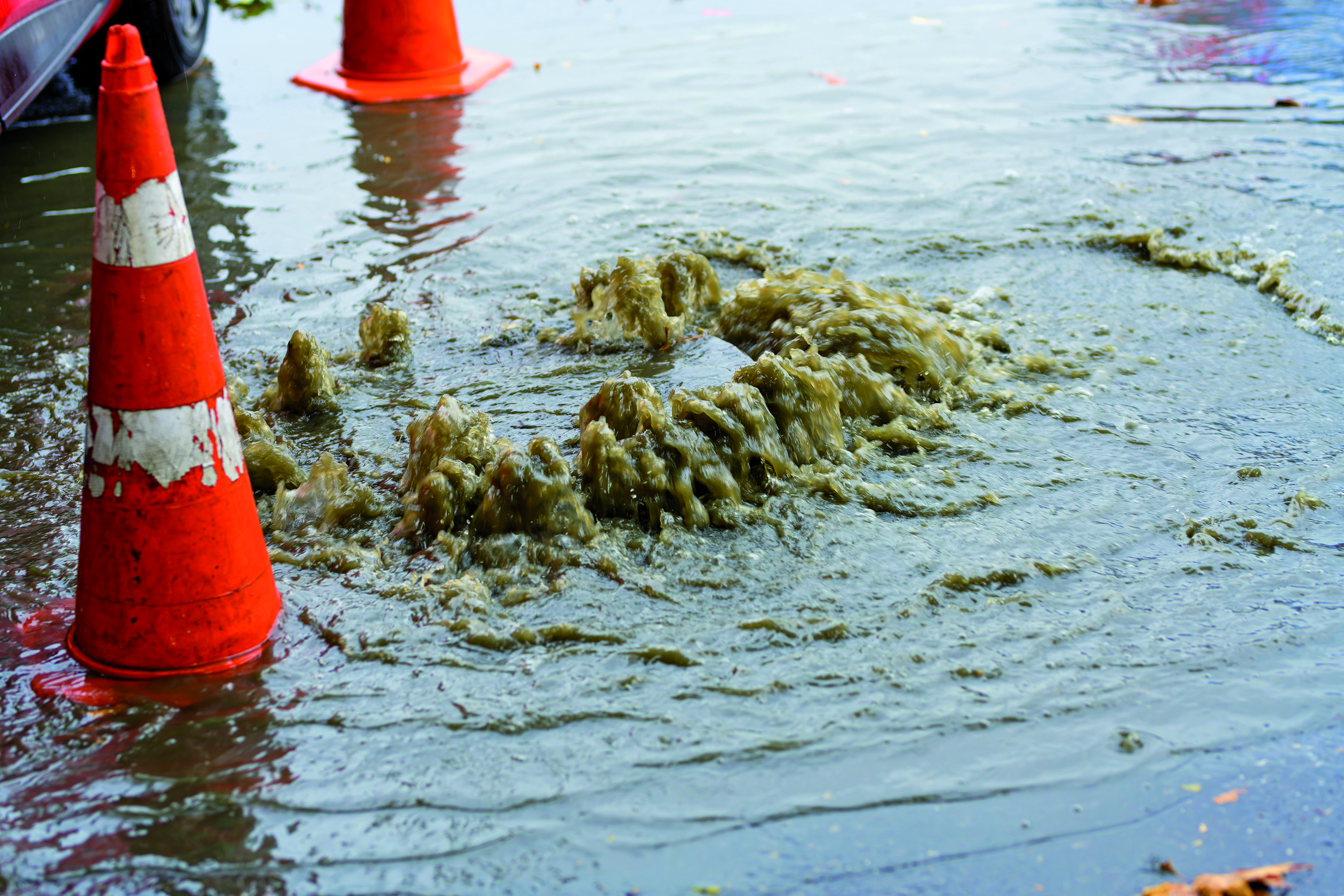
In 2021, the flooding disasters in the Ahr and Erft valleys demonstrated in the most graphic way how vulnerable transport infrastructures really are when they extend through a topographically unfavourable valley location exposed to extended heavy rain events causing flash floods and floodwater. Numerous bridges and roads were damaged or destroyed and have required reconstruction. Countless transport links suffered disruption for weeks and months; in some cases they still suffer disruptions. Nevertheless, even short-lived precipitation events can seriously impact road transport. In June 2021 for instance, roads had to be closed in Landshut, Darmstadt, Krefeld and Magdeburg owing to violent tempests, either because they were inundated by floodwater or swamped by mudslides so that they had to be cleared before they could be re-opened to traffic.
The DWD issues warnings when such sudden and intensive rain events are expected necessitating such closures, by using the term ‘heavy rain’ in their warnings. Such events can be over in a relatively short time period (according to the DWD warning criteria these events can last up to 6 hours), and more often than not, they occur in a limited locality. In Germany the heavy rain season comprises the months of May to September, and is most significant in the months of June to August. Heavy rain events occur often combined with violent thunderstorms; the technical term for this is ‘convective precipitation events’.
Such short and violent rain events can have grave impacts on the transport infrastructure and traffic flows. The nature of these consequences and the specific damage caused, depend on the specific location as well as the relative intensity and duration of rainfalls. On level ground the water cannot run off quickly, and the soil is unable to absorb it completely. The result can be long-term flooding of roads in trough-like hollows and underpasses. That is where water will collect when it can no longer be absorbed and conducted away by drainage systems. As a rule, in upland or alpine regions, depending on the incline, water tends to run off the surface quite rapidly. Very violent heavy rain can turn minor streams into torrential rivers, where rising flood waves force their way through narrow beds of streams. Time and again, the tail ends of these flash floods reach areas which had not actually been affected by heavy rain. In extreme cases, the flow of the massive water runoff or, as described above, high water pressure can damage infrastructures.164 164
More frequently it happens that given such poor road conditions and visibility, accident hazards increase, as for instance in respect of aquaplaning. Equally, heavy rain events can cause obstacles in the road, for instance when driftwood or other flotsam gets stuck in a bottleneck at bridges or underpasses causing logjams and congesting the transport network. Obstructions can also occur when after heavy rainfall slopes and embankments start slipping or are washed out thus covering roads in mud or damaging them in some way.
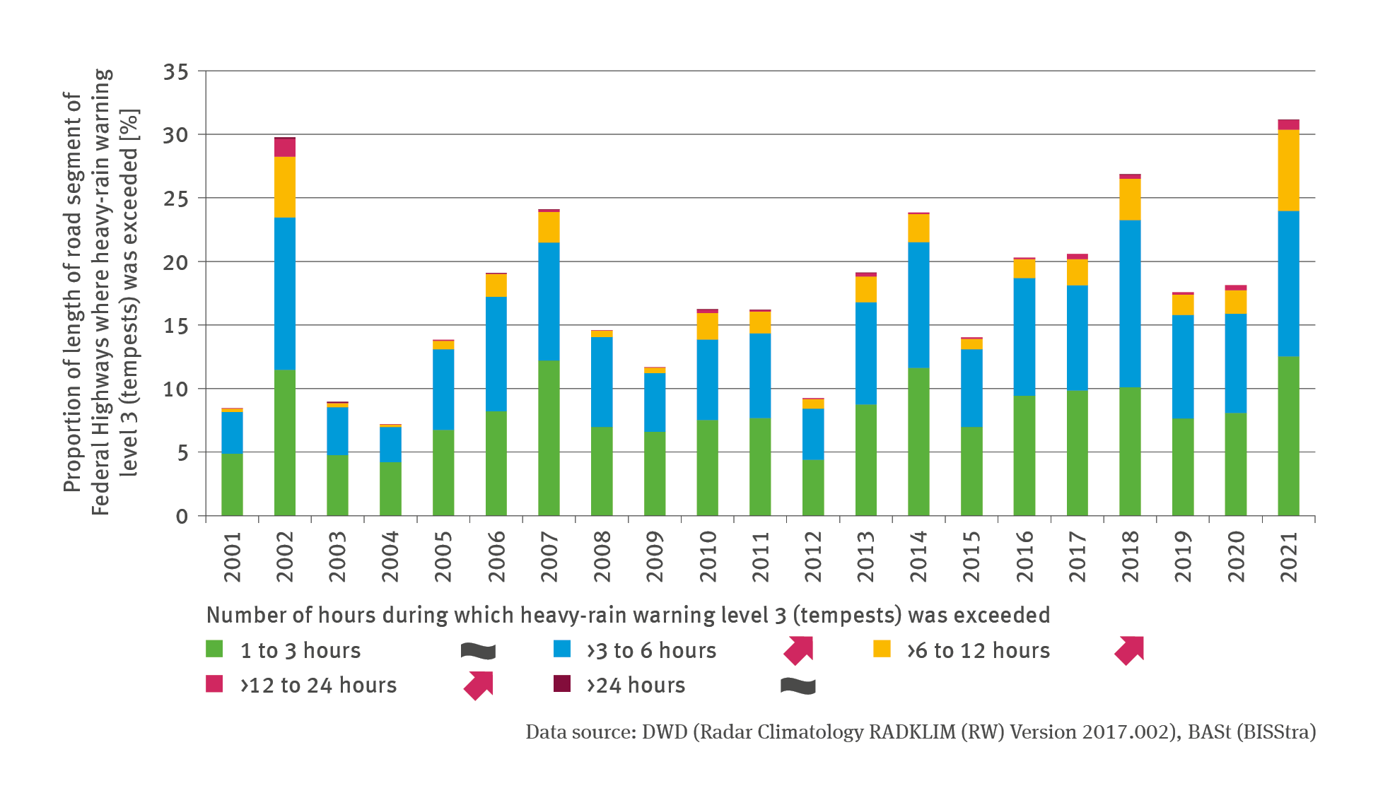
Between 2001 and 2021 heavy rainfalls have occurred practically all over Germany. It seems obvious therefore that this phenomenon is not limited to upland or mountain areas. This is reflected in the outcomes of an assessment based on the DWD’s radar climatology (RADKLIM).165 It is expected by climate researchers that in future the frequency of heavy rain and its intensity will in general increase. One reason for this is that at higher temperatures the air can absorb more water – approximately 7 % more water at a temperature increase by one Kelvin. Furthermore, the changing meteorological conditions give rise to the intensified formation of clouds and precipitation.166 As far as Germany is concerned, it is expected that especially in the second half of the 21st century, there will be – albeit with major regional and seasonal differences – more instances of daily rainfall in high quantities and frequencies compared to the relatively low values recorded in current times. The comparatively strongest increase is expected for events which are currently still infrequent.167 If these developments materialise, the risk of road traffic disruptions and – in extreme cases – damage to roads and infrastructures will increase. So far, there are no data in the public domain which might enable a reliable and cause-related illustration of the extent of such disruptions and damage. Therefore, the indicator illustrated here in this context provides ‘just’ an insight into the temporal extent to which the network of federal trunk roads was affected by tempest-type heavy rainfalls as recorded by means of radar data for specific spatial areas. In other words, the indicator is limited to describing just the risks involved.
It is not very likely that infrastructures would be damaged in all heavy rain events covered by the indicator. The DWD issues warnings against tempest-like heavy rain whenever rain amounts of more than 25 litres per square meter (l/m²) are expected to fall in one hour, or when more than 35 l/m² are expected to fall in 6 hours. If these warning levels are exceeded in only moderate amounts, the intensity of heavy rain is usually not likely to damage traffic infrastructures. However: the DWD marks weather situations as warning level 3, i.e. ‘tempests’ when they are categorised as very hazardous, in which case the DWD recommends that people avoid venturing outdoors.
164 - BBK – Bundesamt für Bevölkerungsschutz und Katastrophenhilfe (Hg.) 2015: Die unterschätzten Risiken „Starkregen“ und „Sturzfluten“ – Ein Handbuch für Bürger und Kommunen. Bürgerinformation, Ausgabe 1, Bonn: 27. https://www.bbk.bund.de/SharedDocs/ExterneLinks/DE/Download/starkregen-publikation-kurzlink.html
164 - LAWA – Bund/Länder-Arbeitsgemeinschaft Wasser (Hg.) 2018: LAWA-Strategie für ein effektives Starkregenrisikomanagement. Erarbeitet von der Kleingruppe „Starkregen“ des Ständigen Ausschusses „Hochwasserschutz und Hydrologie“ (LAWA-AH) der LAWA. Potsdam 2024, https://www.lawa.de/documents/lawa-strategie-srrm-final-barrfrei_1726058183.pdf.
165 - Winterrath T., Brendel C., Hafer M., Junghänel T., Klameth A., Lengfeld K., Walawender E., Weigl E., Becker A. 2018: RADKLIM Version 2017.002: Reprozessierte, mit Stationsdaten angeeichte Radarmessungen (RADOLAN), Niederschlagsstundensummen (RW). doi: 10.5676/DWD/RADKLIM_RW_V2017.002
166 - Becker P., Becker A., Dalelane C., Deutschländer T., Junghänel T., Walter A. 2016: Die Entwicklung von Starkniederschlägen in Deutschland – Plädoyer für eine differenzierte Betrachtung: 1. https://www.dwd.de/DE/fachnutzer/wasserwirtschaft/entwicklung_starkniederschlag_deutschland_pdf
167 - LAWA 2018, cf. endnote no. 164