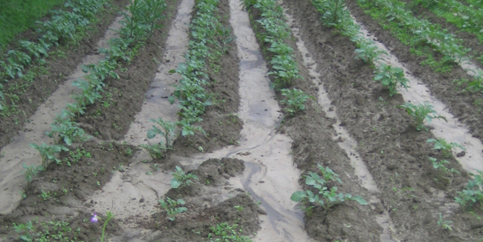
Potato dams in the downslope direction force soil loss by water. Source: Stephan Marahrens / Umweltbundesamt
Uncovered soils are exposed unprotected to the energy of water during heavy and prolonged rainfall. The water transports the soil irretrievably downhill. As a result, fertile soil is lost, and therefore the yielding capacity on arable land. In addition, the eroded material and the absorbed nutrients and pollutants can pollute neighboring water bodies.
During heavy rainfall, especially after prolonged drought, unprotected soil on agricultural land without adequate plant cover can be eroded. The soil particles are denuded or transported in linear forms downslope. Depending on the intensity of a rain event, the material is transported over short or long distances. In this process, it may reach adjacent water bodies or neighboring land areas (Figure 1). Linear forms are mostly oriented to drainage and depth contours as well as to driving and cultivation tracks.
In Central Europe, images of completely eroded land surfaces are currently unknown. In Germany, however, soil loss by water occurs on many agriculturally used areas such as arable land, areas with permanent crops e.g. viticulture and orchards.
What favors soil loss by water?
The natural susceptibility of soils to soil loss (potential soil loss), i.e., soil types, humus content, and aeration, as well as terrain characteristics and climatic factors naturally determine the hazard potential for the erosive action of water. However, the determining factor in the extent of soil loss is agricultural use. Crop rotation design, tillage intensity, and tillage direction, as well as field size and the associated slope length, determine the amount of soil loss.
Erodibility of soil: Soils with high proportions of fine particles, such as the grain size "silt" (predominant in loess soils), are particularly susceptible to soil loss. Higher humus contents and a higher proportion of stones on the surface provide protection from the raindrops. In addition, active soil life provides many vertical soil pores and stable microstructures. Small tubes, such as those made by earthworms, can accelerate the infiltration of rainwater and reduce runoff on the surface and thus soil loss.
Terrain: In principle, soils on slopes bear a significantly higher risk of soil loss. But soil loss can start at slopes as steep as two percent. In addition to the slope, the slope length is crucial. The longer the water flows without barriers and obstacles, the greater the risk. With steep slopes, however, even short flow lengths have a high risk of erosion.
Climatic conditions: Both prolonged low-intensity precipitation and the frequency of heavy rain and thundershowers are crucial for soil loss.
As a general rule, heavy rainfall combined with highly soil loss-prone soils on unprotected slopes means a high risk of soil loss by water.
Important management-related factors are ultimately reflected in the degree of soil cover and the type and intensity of tillage. They provide a measure of the actual soil loss risk.
Soil cover: Uncovered or only slightly covered soils due to cultivation offer a favorable surface for water to attack and its erosive effect. A soil cover of around 30 percent or more already counteracts soil loss by water (see also UBA topic page " Erosion – any soil crumb counts").
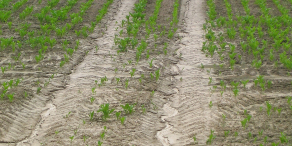
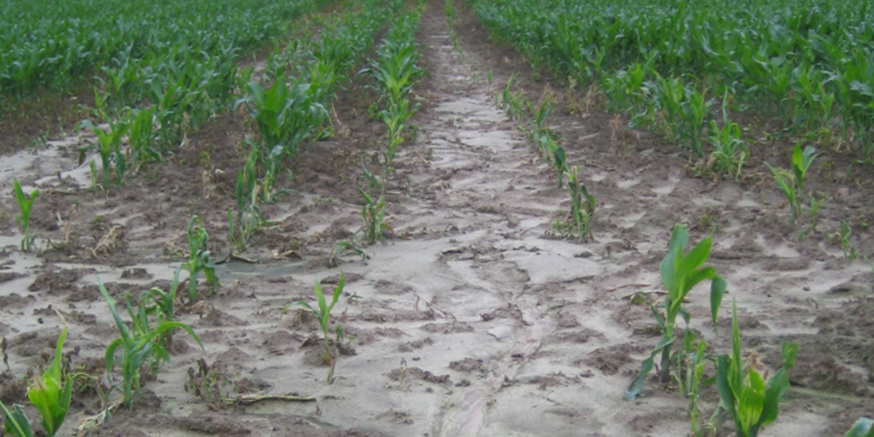
Tillage: As tillage intensity increases, so does the soil loss risk. Non-rotational tillage leaves more crop residues on the soil, which can protect against the impact energy of water. It also protects the soil structure, for example, in the form of vertical tubes for rainwater infiltration and soil stability. The direction of tillage and cultivation is also important. Tillage in downslope direction increases the soil loss risk, while slope parallel tillage protects the soil. This is especially true for ruts on croplands (Figure 2, Figure 3).
On the field level both, the natural (potential) soil loss susceptibility and the management-related soil loss risk are important. Especially on soils of high natural erodibility risk, soil loss-reducing management practices are essential to prevent soil degradation.
Figure 2. Ruts in the downhill direction promote soil loss by water. Source: Stephan Marahrens / Umweltbundesamt
Figure 3. When growing corn, the soil is uncovered for a long time and is susceptible to soil loss and siltation. Source: Stephan Marahrens / Umweltbundesamt
How much soil is lost due to soil loss by water in Germany?
Every year, on average for Germany, a total of around 25 million tons of soil are removed by soil loss through water. Of this, around 22 million tons come from arable land and 1.4 million tons from vineyards. The rest is due to soil loss, primarily from forest areas and open areas such as mountainous terrain.
The generally accepted "Universal Soil Loss Equation (USLE; German: ABAG)" is used for the nationwide consideration of the soil loss risk due to water on arable land as well as for the balancing of the long-term average annual soil loss due to surface and rill erosion (tons per hectare per year). The USLE takes into account both the natural factors influencing the potential soil loss (soil properties, climate and terrain) and the influence of management such as the crops grown and tillage (see Figure 4).
The geoscientific and pedological institutions usually identify the potential soil loss risk. The Federal Institution for Geosciences and Natural Resources (BGR) is responsible for this. Currently, an evaluation based on the Soil Map at a scale of 1:1,000,000 (BÜK 1,000) is available (BGR - Potentielle Gefährdung (bund.de)).
On behalf of UBA, the actual long-term average soil erosion was recalculated using the general soil erosion equation (ABAG) on the basis of current, nationally harmonised, high-resolution data. Important data bases used were:
Soil Map at a scale of 1:200,000 (BÜK200) from the BGR
Rainfall erosivity of the German Weather Service (DWD, RADKLIM in a 1 kilometer grid); Auerswald et al. 2019 and Fischer et al. 2019
Digital Terrain model in a 10-meter grid of the Federal Agency for Cartography and Geodesy (BKG).
Information on crop cultivation (crop types and proportion of conservation tillage).
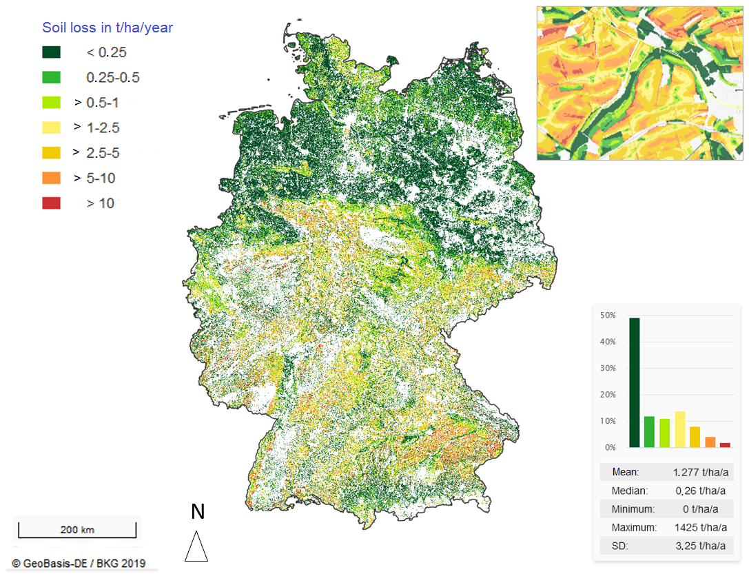
Nationwide soil loss calculation results are available on the spatial resolution of a 10 meter grid (see Figures 5 to 9).
Figure 5: Rainfall erosivity factor (R-factor) of the Universal Soil Loss Equation (USLE) according to Auerswald et al. 2019 and Fischer et al. 2019. Source: Home - MoRE viewer
Figure 6: Factor of soil erosivity (K-factor) of the Universal Soil Loss Equation (USLE) Source: Home - MoRE viewer)
Figure 7: Slope length and slope inclination factor (LS factor) of the Universal Soil Loss Equation (USLE), with detail view (top right) Source: Home - MoRE viewer
Figure 8: Cover and tillage factor (C-factor) of the Universal Soil Loss Equation (USLE) Source: Home - MoRE viewer
Figure 9: Mean long-term soil loss by water erosion in Germany calculated based on the Universal Soil Loss Equation (USLE) from agricultural land a, with detail view (top right); non-agricultural land appears white. Source: Home - MoRE viewer
All results, including the derived factors of the Universal Soil Loss Equation (USLE), are included in the following tool and are also available for download.
Protection against soil loss is also water protection
A relevant portion of the soil mobilized on agricultural land reaches connected surface waters and can cause problems there like eutrophication. In addition to the input of pollutants adhering to the soil material, the sediment quantities themselves can cause high costs, for example in impoundments.
The calculation of the sediment input to surface waters (Figure 10) considers soil losses from agricultural areas as well as from areas either with natural vegetation cover or without vegetation cover (e.g. alpine areas). Based on the soil loss, factors such as natural and infrastructural barriers, the distance to water bodies and the probability that a respective area (plot) is connected to the natural drainage network are considered to determine the sediment input. Sediment from not connected plot are for example completely deposited, on adjacent land areas.
Throughout Germany, about 6 percent of the soil loss, or approximately 1.6 million tons, is discharged into surface waters. Of this, 1.4 million tons come from arable land and about 62,000 tons from vineyards.
After linking the results with information on the nutrient and pollutant load of the soil particles, they are also used for nationwide substance input modeling with the MoRE (Modeling of Regionalized Emissions) tool (see UBA topic page "Pollutant emissions into surface waters").
Measures to reduce erosion by water
To prevent soil loss by water, a large number of plant cultivation and operational measures exist within the framework of "good professional practice" according to § 17 of the German Federal Soil Protection Act (BBodSchG). However, these measures are not sufficiently specified either in the Federal Soil Protection Act or in the German Federal Soil and Contaminated Sites Ordinance (BBodSchV).
The Common Agricultural Policy of the European Union (CAP) also lists minimum requirements for soil loss protection on endangered land in the so-called standards for maintaining agricultural land in "good agricultural and ecological condition" (GAEC), in relation to the receipt of direct payments from the EU agricultural budget.
An effective individual measure for reducing soil loss by up to 50% compared to conventional turning tillage is permanent conservation tillage, which has been continuously developed and now represents the state of the art.
Scenario calculations on the effects of climate change show increasing soil loss, e.g. as a result of increasing precipitation intensity or a shift in the vegetation periods due to a change in the annual cycle of temperature, can be at least partially compensated for with known measures, such as cultivation across the slope, year-round soil cover if possible and decreasing field size.
Sources
Auerswald K., Fischer F.K., Winterrath T., Brandhuber R. (2019): Rain
erosivity map for Germany derived from contiguous radar rain data.
Hydrol. Earth Syst. Sci., 23, S. 1819–1832.
Fischer F.K., Winterrath T., Junghänel T., Walawender E., Auerswald
(2019): Mean annual precipitation erosivity (R factor) based on
Gebel, M.; Allion, K.; Plambeck, N. O.; Fuchs, S.; Ullrich, A. (2021): Deutschlandweite hochaufgelöste Modellierung von Sedimenttransfers in die Oberflächengewässer zur Ableitung partikelgebundener Phosphoreinträge. In: KW - Korrespondenz Wasserwirtschaft 14 (7), S. 413–417.